


Last update
5 Apr 2001

This page is maintained by
Mark Fielding
All content Copyright © The University of Reading unless otherwise stated.
Deriving cloud overlap statistics from radar
Robin Hogan and Anthony IllingworthIntroduction
- The predictions of climate models are sensitive to the assumed overlap of clouds within a vertical column of model gridboxes, but until now no reliable observations of the degree of cloud overlap have been available.
- The three common approaches used by models are depicted in the
schematic below:
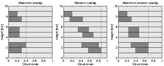
It can be seen immediately that the radiatively-important total cloud cover predicted by the three schemes (indicated by the vertical dotted lines) is very different, even though the cloud fraction at each level is the same. Most models now use the maximum-random overlap assumption, where clouds in adjacent model levels are deemed to be maximally overlapped, while clouds separated by an entirely cloud-free model level are deemed to be randomly overlapped.
Method
- Observations by the 94 GHz
Galileo cloud radar have been used to quantify the extent of
cloud overlap for use in models. Quicklooks can be found here.
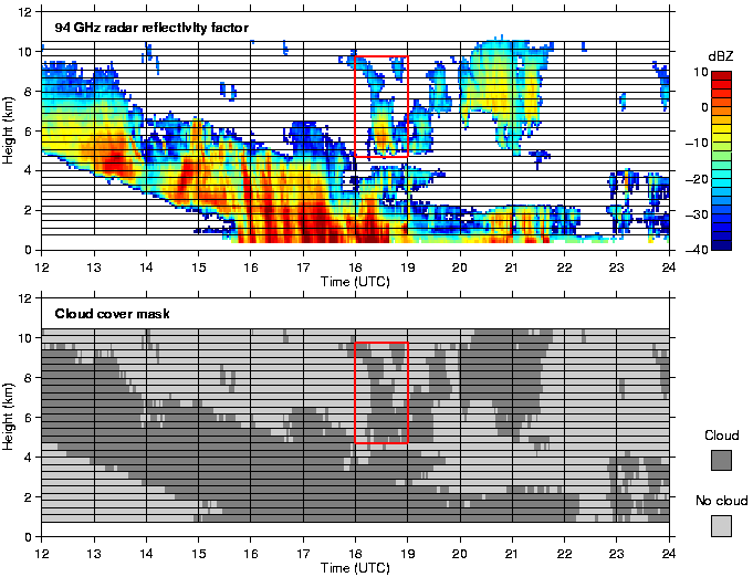
- The cloud enclosed by the red box in the figure above is an example of a cloud that is `vertically continuous', yet is certainly not maximally overlapped as would be predicted by most current models. Note that the concept of overlap is meaningless when grid boxes are entirely cloudy since all overlap assumptions must predict the same total cloud cover: 100%.
- Seventy-one days of near-continuous radar observations such as these have been analysed. Cloud overlap has been determined by calculating the `combined cloud cover' of clouds in pairs of adjacent and non-adjacent levels.
- This is compared with the overlap schemes used in models by defining an overlap parameter which expresses the mean overlap of layers a particular vertical distance apart, relative to random and maximum overlap. For exactly random overlap the overlap parameter is defined to be 0 and for exactly maximum overlap it is 1.
Results
- The results are shown in the figure below:
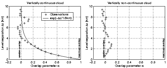
- For vertically non-continuous cloud (right panel) we see that for all level separations the overlap is very close to random on average, in agreement with the assumptions made in current models.
- For vertically continuous cloud on the other hand (left panel), overlap tends to move from near-maximum when the levels are adjacent to near-random at separations of greater than 4 km. This is in contrast to most current models which assume maximum overlap for vertically continuous cloud.
- In this case the overlap parameter is seen to be well approximated by a simple inverse exponential, which could be useful for parameterising the behaviour in models. It is found that the e-folding distance for the overlap is a function of the size of the grid boxes used in the analysis, and therefore on the resolution of the model.
Reference
- Deriving cloud overlap statistics from radar
Hogan, R. J., and A. J. Illingworth, 2000, Quart. J. Roy. Meteorol. Soc., 126(569A), 2903-2909. (Download from the Publications page)