


Last update
6 Oct 2002

This page is maintained by
Mark Fielding
All content Copyright © The University of Reading unless otherwise stated.

Kelvin Helmholtz Billows
Danny Chapman and Keith BrowningIntroduction
When (potentially) warm air lies above colder air, the interface between the two air masses is statically stable. However, if a vertical wind shear exists across the interface, so the two air masses are in relative motion, then the interface can become dynamically unstable. The waves that develop are known as Kelvin-Helmoltz billows, and may occur in stably stratified layers when the Richardson Number (Ri) falls below 0.25. The Richardson number is defined as the ratio of the static stability, N2, to the square of the vertical wind shear.
KH billows occur fairly frequently in the atmosphere, with wavelengths up to a few kilometers. As they induce vertical air motion, they sometimes cause billow clouds. They can also occaisionally be seen on the top of stratiform clouds, with the cloud droplets acting as a tracer (like my animation above). They may also be observed when they occur in the clear air, by using high power radar or by making measurements from aircraft-borne instruments. Such observations have linked KH billows to clear-air turbulence (CAT), making their prediction important for aviation safety. They also act to mix across considerably vertical depths (up to around 1km) and dissipate energy. Estimates of the energy dissipated by billows at high levels in the troposphere indicate that they could have a significant impact on the larger-scale dynamics.
The onset and structure of billows occuring in idealised conditions has been studied in considerable detail using analytical, numerical and laboratory models. However, it is not always clear how these results apply to billows in the real atmosphere. There have been few observations of billows in the atmosphere which have shed light on what their detailed structure is, and how they evolve with time. The case described below is able to do this, thanks to the high resolution of the data that were obtained using the Doppler radar at Chilbolton.
The 3GHz Chilbolton research radar has an angular resolution of 0.28 degrees, and a range reolution of 300 m. It is fully Dopplerised so that the radial velocity spectrum of the precipitation targets can be obtained. Since falling rain and cloud droplets will follow the horizontal wind field, this enables the radial component of the wind field to be measured to an accuracy of better than 0.1 m/s in regions of precipitation. In spite of the limitations of having only the line of sight velocity component, making realistic assumptions such as incompressibility and knowing the broad structure of the weather event being observed can sometimes allow the other components to be derived.
Billows within a precipitating warm frontal zone.
On 6th September 1995 a warm front approached Chilbolton radar. At around 2200 UTC the surface front was located around 50 km to the south of the radar, and it was orientated approximately west-east. The frontal zone thus sloped northwards and upwards, with a slope of around 1:100. underneath this zone cold air travelled westwards, above the zone warm air travelled eastwards. KH billows existed in the stably stratified frontal zone between the warm and the cold air.
The figure below is a vertical cross-section (with an expanded vertical scale) orientated west-east, parallel to the surface front. The colors show the Doppler velocity measured by the radar, which is effectively equal to the west-east component of the wind. The blue shading indicates that the air near the ground was moving to the west with a speed of about 10 m/s, and the red shading indicates that the air at an altitude of around 2 km was moving to the east with a speed of about 10 m/s. This is a cross-section through a warm frontal zone, so the red shading also happens to indicate warm air, and the blue indicates colder air.
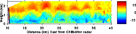
The cross-section clearly shows a disturbance (ie the billows) with a wavelength of around 4 km. Other observations reproduce this, and also indicated that the billows were orientated almost exactly parallel to soth-north, with little variation along their length (ie in a south-north direction). This orientation was due to two factors: (a) they had a west-east phase speed which was zero relative to the ground, and (b) there was a south-north component of wind relative to the surface front, which was itself moving northwards. As the billows evolved, they moved northwards, but there was continuous generation of billows at a location around 40 km north of the surface front.
As there is no significant variation in v in the south-north direction, the continuity equation (du/dx+dv/dy+dw/dz=0, ignoring density variations) can be integrated upwards from the surface to give the vertical velocity field in this cross-section. This has been done (including density variations in the vertical) and is shown below as a plot of streamfunction (ie air parcels follows the streamfunction lines) in the plane of the cross-section:
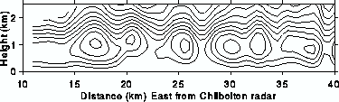
At heights around 2 km air parcels move from west to east, undulating in height as they do so. However, at around 1 km air parcels move in approximately elliptical 'orbits' in this plane, mixing the warm air into the cold air region and vice versa. Irreversible mixing occurs when convection occurs at smaller spacial scales than the billows themselves. This is consistent with results of numerical and laboratory tank experiments, but appears to be the first time that the 3-dimensional air motion within billows in the atmosphere has been quantitatively derived.
Other dynamical properties of these billows have been examined, such as the distribution of vertical shear of the horizontal wind, du/dz:
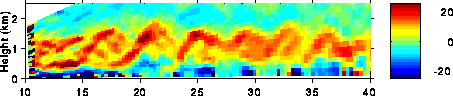
This shows that the original shear layer (shaded red), which would have been horizontal before the billows had developed, has been distorted and broken into overlapping segments or braids in the left half of the section. The pattern is qualitatively very similar to the characteristic "braids" observed in clear-air radar observations of billows. Observations made at different times as the billows passed over the radar shed light on their evolution, and the effect they have on the depth of the shear layer. It appears that they approximately doubled the depth of the interface, which is a considerable effect on the structure of the front.
References
- Radar observations of wind-shear splitting within evolving
atmospheric Kelvin-Helmholtz billows
Chapman, D., and K. A. Browning, 1997, Quart J. Roy. Meteorol. Soc., 123(541A), 1433-1439. - Release of potential shearing instability in warm frontal
zones
Chapman, D., and K. A. Browning, 1999, Quart J. Roy. Meteorol. Soc., 125(558B), 2265-2289.